

Residential Land For Sale
$11,504
304 Lucky Drive
Florahome, Florida, United States
0 acres
Listed By: Landcentury
Listed On: 09/13/2024
Listing ID: GL10758637
Description
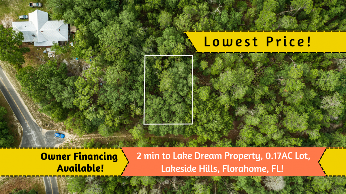
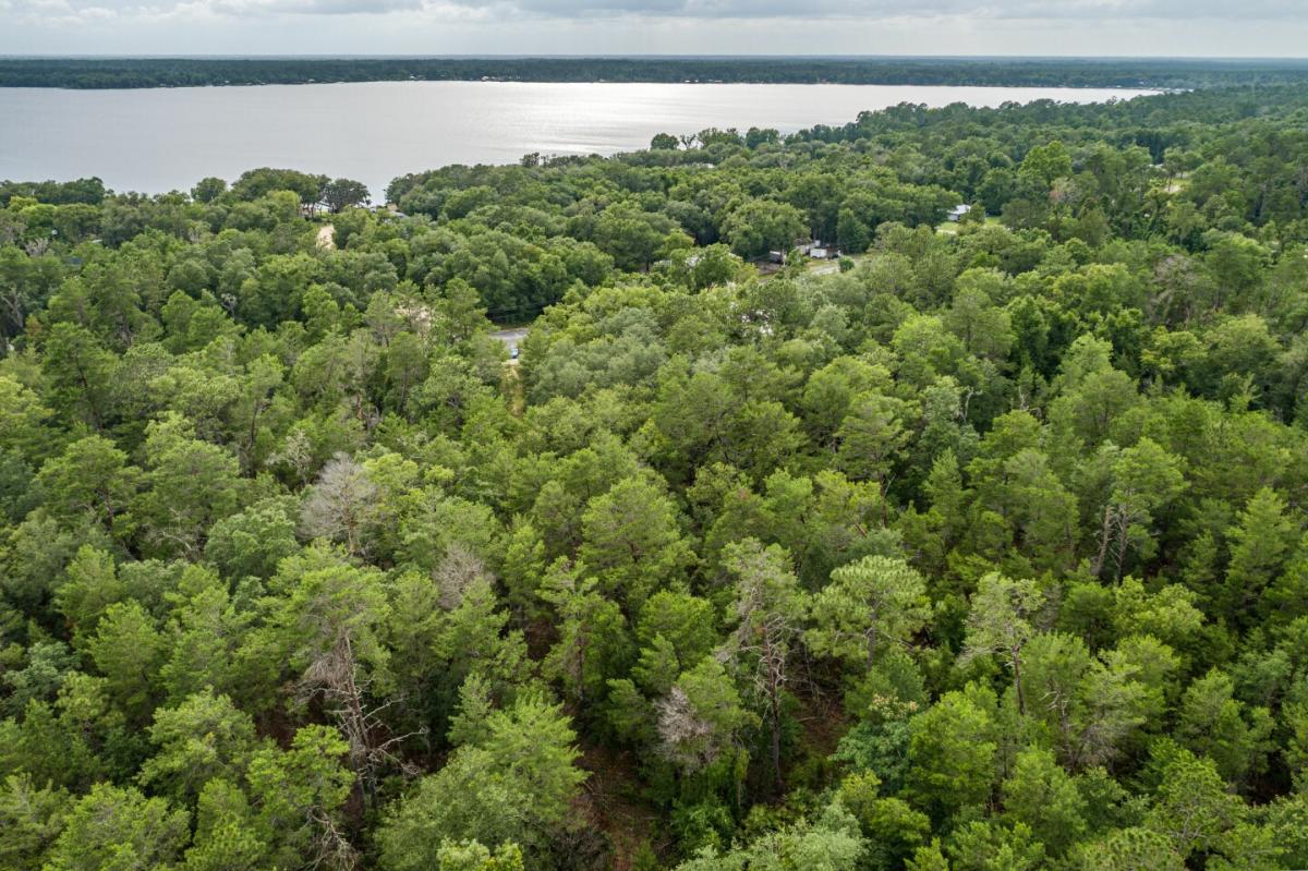
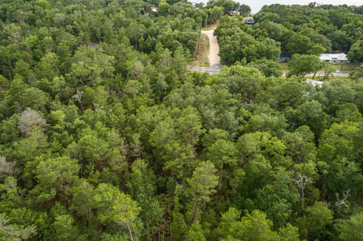
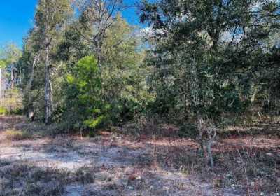
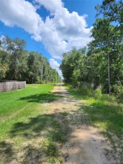
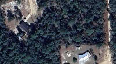
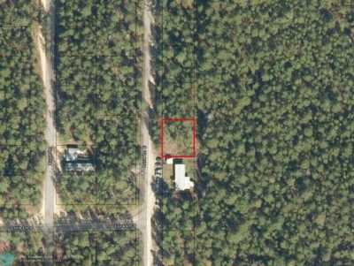
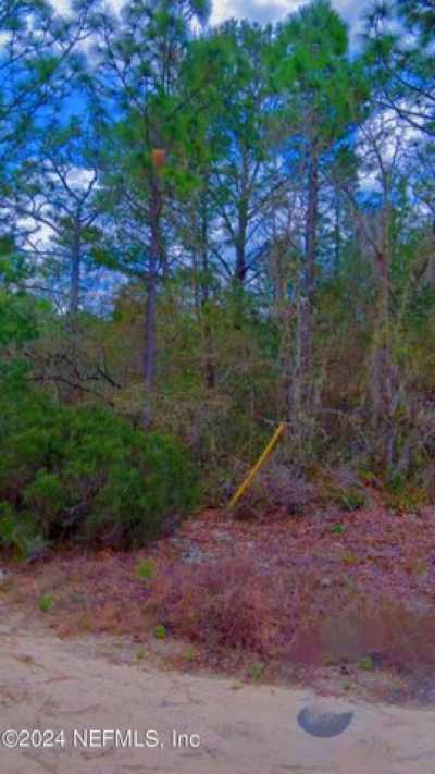
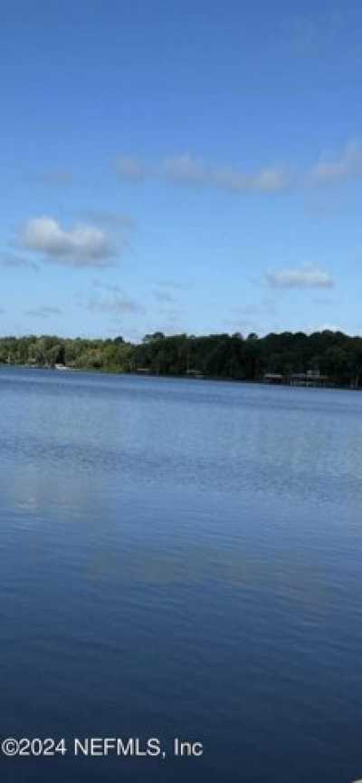
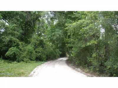
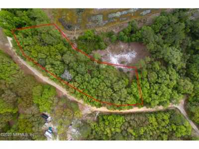
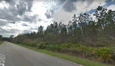
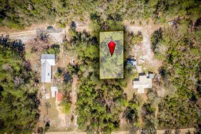
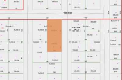
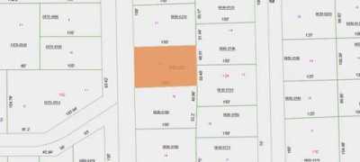
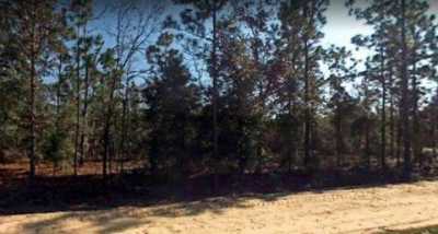
A slice of AFFORDABLE peaceful paradise! This vacant land lot in Putnam County could be the answer to your dreams! Located in Lakeside Hills, this 0.17 Acre lot is surrounded by beautiful natural scenery, super close to Georges Lake (maybe a stone’s throw away?) and is the ideal location to build your dream home or holiday escape. RVs are allowed 2 months at a time. With easy access via a dirt road, you'll enjoy both privacy and accessibility. Here you'll experience mild temperatures all year round, and with close proximity to nearby cities such as Ocala, Palatka, Gainesville, and Jacksonville, you'll have easy access to all the amenities you need. Plus, at $2 per month, your property taxes will never approach never mind break the bank! Whether you're looking to retire, relocate, or invest in your future, the possibilities are endless with this fantastic parcel of land. Florida is home to some of the best beaches and outdoor attractions, so you can enjoy all the great outdoors has to offer. Why wait? Grab this opportunity to own a unique piece of paradise today! Call us now before it's too late. Don't Wait to Buy Land, Buy Land and Wait. Land like this WON’T LAST! Contact REAL DEAL LOTS Now and find out how YOU can Become a Successful Land Owner in Just a Few Simple Steps. Pricing Details: Discounted Cash Price: $9,485.00 Property Details: Size: 0.17 acre APN: 18-08-25-5106-6080-0050 State: FL County: Putnam Property Address: 304 Lucky Dr, Florahome, FL 32140 General Elevation: 139 ft. GPS Center Coordinates: 29.793388293200493, -81.83508885564504 GPS Coordinates (4 corners): 29.793544367309, -81.83499249659 NE 29.793262135899, -81.83523925983 SW 29.793265045505, -81.83498579107 SE 29.793542621550, -81.83524261259 NW HOA: NO HOA Property Annual Tax: $24.93 Back Taxes Owed? If so, amount owed: Zoning: R-1A (Residential, Single-Family) Flood zone: Not in Flood zone area Wetlands: No Wetlands Terrain type: Flat and Level Access to property: Dirt road via Lucky Dr Road surface/type: Dirt Building Information: What can be built on the property? Residential – Single Family Time limit to build? Within 180 days of the date of the issuance of the building permit. Building Allowances/Restrictions: Single-Family, site-built and modular detached single-family housing, Community residential homes, Bed and breakfast. Minimum lot area of 7,500 sq ft, Minimum lot width of 75 ft, and Maximum building height of 35 ft. Setbacks are: Front: 25 ft., Rear: 20 ft., Side: 10 ft. Is camping allowed? Allowed for recreational use but must ensure a permit. Are RV's allowed? RVs allowed as a temporary shelter on property. Pursuant to a temporary use permit during land clearing of the site where the recreational vehicle is to be located. The maximum duration of the temporary use permit for this purpose shall be 60 days. Are mobile homes allowed? No. UTILITIES: Power: Electric on the road (Clay Electric Cooperative, Inc: 800-224-4917) Water: Well Required Sewer/Septic: Septic Needed Gas: Putnam Propane Inc (800-515-8391) Nearby Cities: Closest major city: Gainesville (45 min, 36.9 miles) Jacksonville (1 hr. 4 min, 60 miles) Ocala (1 hr. 5 min, 57.4 miles) Closest small town: Interlachen (25 min, 17.9 miles) Palatka (30 min, 24.2 miles) Hawthorne (36 min, 28.4 miles) Nearby attractions: Georges Lake (2 min, 0.1 miles) Mike Roess Gold Head State Park (21 min, 15.4 miles) Devil's Millhopper State Geological Site (53 min, 41.6 miles) Castillo de San Marcos (1 hr. 7 min, 53.3 miles) Driving Directions: From Gainesville: Take FL-26 E/E University Ave for 3.8 miles. Slight left onto FL-26 E/NE 55th Blvd for 3.4 miles. Then turn right onto FL-26 for 16.8 miles. Turn right onto State Rte 100 E for 5.0 miles. Turn left onto Coral Farms Rd for 5.2 miles. Turn right onto S Bellamy Rd for 0.9 miles. Then turn right toward Hillsborough Ave for 195 feet and immediately continue by turning left at the 1st cross street which again is Hillsborough Ave for 1.8 miles. Turn left onto Lucky Dr. Property lot will be on the left. Use the GPS Coordinates to find the location From Jacksonville: From Kings Rd, take FL-228 W/I-95 S/US-17 S toward I-10 for 0.5 miles. Use the right 2 lanes to take exit 352D for Interstate 10 W toward Lake City for 0.8 miles. Turn right at the fork (signs for Stockton St) and continue onto I-10 W for 10.8 miles. Then use the right 2 lanes to take exit 350 for FL-23 S and continue onto FL-23 for 16.4 miles. Use the right 2 lanes to take exit 31 to merge onto FL-21 S/Blanding Blvd/State Rd 21 S toward Blanding Blvd/Middleburg for 17.6 miles. Turn left onto County Rd 315C S for 5.2 miles. Turn left onto County Rd 315 S/Christian Camp Rd for 1.4 miles. Turn left onto S Bellamy Rd for 4.0 miles. Then turn right toward Hillsborough Ave for 195 feet and immediately continue by turning left at the 1st cross street which again is Hillsborough Ave for 1.8 miles. Turn left onto Lucky Dr. Property lot will be on the left. Use the GPS Coordinates to find the location From Ocala: Take US-301 N/US-441 N/N Pine Ave for 10.6 miles. Keep right to continue on US-301 N, follow signs for Starke for 20.6 miles. Slight right onto SE County Rd 219A for 6.6 miles. Turn right onto FL-26 E for 6.7 miles. Turn right onto State Rte 100 E for 5.0 miles. Turn left onto Coral Farms Rd for 5.2 miles. Turn right onto S Bellamy Rd for 0.9 miles. Then turn right toward Hillsborough Ave for 195 feet and immediately continue by turning left at the 1st cross street which again is Hillsborough Ave for 1.8 miles. Turn left onto Lucky Dr. Property lot will be on the left. Use the GPS Coordinates to find the location From Interlachen: From FL-20 E, go north onto County Rd 315 N for 7.6 miles. Turn right onto State Rte 100 E for 1.9 miles. Then turn left onto Coral Farms Rd for 5.2 miles. Turn right onto S Bellamy Rd for 0.9 miles. Then turn right toward Hillsborough Ave for 195 feet and immediately continue by turning left at the 1st cross street which again is Hillsborough Ave for 1.8 miles. Turn left onto Lucky Dr. Property lot will be on the left. Use the GPS Coordinates to find the location From Palatka: Take State Rte 100 W/Reid St for 15.1 miles. Then turn right onto Coral Farms Rd for 5.2 miles. Turn right onto S Bellamy Rd for 0.9 miles. Then turn right toward Hillsborough Ave for 195 feet and immediately continue by turning left at the 1st cross street which again is Hillsborough Ave for 1.8 miles. Turn left onto Lucky Dr. Property lot will be on the left. Use the GPS Coordinates to find the location From Hawthorne: From the Town Centre, go north on US-301 N/N Main St for 1.9 miles. Slight right onto SE County Rd 219A for 6.6 miles. Turn right onto FL-26 E for 6.7 miles. Turn right onto State Rte 100 E for 5.0 miles. Turn left onto Coral Farms Rd for 5.2 miles. Turn right onto S Bellamy Rd for 0.9 miles. Then turn right toward Hillsborough Ave for 195 feet and immediately continue by turning left at the 1st cross street which again is Hillsborough Ave for 1.8 miles. Turn left onto Lucky Dr. Property lot will be on the left. Use the GPS Coordinates to find the location. Important Notes: – All of the information we have about this Property is contained on our Website Property Page. – We ask that buyers do their own Due Diligence – You can visit any of our properties at any Time. GPS Co-ordinates and Driving Directions Given – Please call the Applicable County offices for any Specific Questions about the Property Disclaimer: Buyer is responsible for verifying all information with the County as to what can and can’t be done with the land. Buyer will need to work with the County to obtain the proper permits if needed. Buyer will also need to confirm the availability of any utilities needed or serviced on the property. Seller makes no warranties or representations about the land, its condition, or what can be built on the lot parcel.Other Land Properties For Sale in Florahome, Florida, United States


Advertisement

Other Properties Near Florahome
- Lake Helen Residential Land For Sale (14)
- Loxahatchee Residential Land For Sale (10)
- West Palm Beach Residential Land For Sale (18)
- Juno Beach Residential Land For Sale (1)
- Riviera Beach Residential Land For Sale (3)
- Palm Beach Residential Land For Sale (4)
- Pinetta Residential Land For Sale (3)
- Hastings Residential Land For Sale (75)
- Loxahatchee Groves Residential Land For Sale (1)
- The Acreage Residential Land For Sale (2)
- Atlantis Residential Land For Sale (1)
- Lake Worth Beach Residential Land For Sale (1)
- Lantana Residential Land For Sale (2)
- Lake Worth Residential Land For Sale (9)
- Barefoot Bay Residential Land For Sale (1)